Propuestas en paisajes urbanos
Proposed for urban spaces
120-02.jpg (41178 bytes)
Sistema de recorridos : / Path systems: naranja; recorridos de conexión con la ciudad / orange: links with the city - azul; recorrido interior del parque / blue: interior of the park
Arquitecta/ Architect:
Isabel Vernia Canuto

120-04.jpg (26030 bytes)
Estado actual del frente urbano-marítimo / Current state of the urban-maritime front


Los proyectos que se muestran son algunos de los desarrollados a lo largo del Master d'Arquitectura del Paisatge, durante los cursos 97-98 y 98-99, realizados en la Escuela Técnica Superior de Arquitectura de Barcelona, bajo la supervisión de su directora la Dra. Arquitecto Rosa Barba i Casanovas y sus profesores colaboradores.

Los proyectos abordan el tema de la planificación y diseño del espacio abierto en la ciudad: un frente marítimo y un parque urbano; temas acotados y próximos a la práctica profesional del momento, pero afrontados desde unos planteamientos atentos a una nueva sensibilidad medio-ambiental, propuestas que nacen de una mirada atenta sobre el lugar, y que en los dos casos pretenden establecer vías de actuación sencillas, alejadas de especulaciones teóricas de difícil aplicación, que sean capaces de ofrecer soluciones reales a problemas acuciantes.

The projects shown here are some of those that were developed in 97/98 and 98/99 on the Master d’Arquitectura del Paisatje [Landscape Architecture] course at the Escuela Técnica Superior de Arquitectura [Architecture faculty] of Barcelona, under the supervision of the Director, Rosa Barba i Casanovas Ph.D. (Architecture), and the teachers.

The projects cover the subject of planning and designing open spaces in the city, such as a sea front, a city park or the surroundings of a building. These subjects are ‘closed’ and are similar to the professional practice of the moment, but they are approached from premises that are alert to a new environmental sensitivity. The projects arise out of an attentive look at the place and employ simple means, far from theoretical speculations that would be difficult to apply, offering real solutions to urgent problems.

120-01.jpg (38683 bytes)
La presencia del parque en la ciudad / The presence of the park in the city
120-03.jpg (27156 bytes)
Vegetación propuesta frente a la existente / Proposed vegetation compared to existing vegetation
120-06.jpg (40990 bytes)
120-07.jpg (17332 bytes)
Propuesta / Proposal: elementos construidos / built elements - elementos vegetales / plant elements

Taller III: "Els nous espais de la ciutat".
Profesores: Manuel Ruisanchez, Isabel Bennasar

Se nos propone plantear intervenciones que den una solución satisfactoria al frente urbano-marítimo que la ciudad de Tarragona vuelca hacia la Playa del Miracle, situada al norte del puerto.

Esta zona presenta importantes factores limitantes a la hora de desarrollar un proyecto convencional de frente marítimo .

-una fuerte pendiente.
-efecto barrera de la línea de ferrocarril Barcelona-Valencia.

Tradicionalmente esta franja de territorio desconectada de la ciudad por el fuerte desnivel y de la playa, por la barrera del ferrocarril, ha permanecido al margen de las actuaciones de remodelación urbana, inmersa en un proceso de deterioro progresivo.

Si bien el proyecto acepta la barrera física que constituye la presencia de las vías de ferrocarril, si se plantea la remodelación de este frente-límite y su incorporación tanto visual como funcional al frente urbano.

El proyecto entiende la zona de trabajo como una pieza más dentro de la red de espacios libres de la ciudad; a su vez forma parte del conjunto de espacios intersticiales del frente urbano, cuya ocupación debido a la fuerte pendiente, ha sido progresivamente aplazada.

Se propone una actuación encaminada a evitar el deterioro del lugar y la progresiva pérdida de configuración física como borde accidentado de la meseta sobre la que se asienta la ciudad. Se entiende esta situación topográfica como un valor añadido al lugar, capaz de enriquecer la diversidad de espacios libres que contiene la ciudad. Se recurre a un mínimo de medios y de materiales para llevar a cabo la actuación, ésta se entiende como un modelado del territorio encaminado a reforzar la estructura topográfica y la vegetal:

La estructura topográfica se trabaja mediante la creación de un continuo de terrazas que recorre todo el ámbito de actuación, y que conecta el núcleo histórico de Tarragona con la zona de ocio del puerto. Las terrazas y los puntos frágiles de mayor pendiente se refuerzan con muros de piedra seca ejecutados a la manera tradicional; únicamente se pavimentan con losa de hormigón las zonas de paso que enlazan las terrazas, estas se ejecutan con un pavimento blando de sauló.

La estructura vegetal se trabaja únicamente con dos elementos: plantaciones de Pinus pinea correspondiendo con las terrazas, ya que estas son las zonas de estancia; y plantaciones de arbustos autóctonos como las distintas variedades de Juníperus acompañando los recorridos entre terrazas.

Workshop III: "The new spaces of the city".
Teachers: Manuel Ruisanchez, Isabel Bennasar

The proposal was to envisage actions to provide a satisfactory solution for the urban seafront of the city of Tarragona at the Miracle beach, located north of the port.

This zone presents major limiting factors for the development of a conventional seafront project:

-a pronounced gradient
-the barrier of the Barcelona-Valencia railway line

This strip of land has traditionally been set apart from the city by the great difference in level and from the beach by the railway line. As a result, it has been excluded from urban remodelling programs and has suffered a progressive process of deterioration.

Although this project accepts the physical barrier of the railway line, it suggests remodelling this edge-front and incorporating it, both visually and functionally, into the urban front.

The project views the site as just another part of the city’s network of open spaces and, at the same time, as part of the set of interstitial spaces of the urban front: here, due to the steep slope, its occupation has been progressively postponed.

The proposed work is intended to prevent the deterioration of the place and the progressive loss of its physical shape as a rough edge of the plateau on which the city lies. Thus the lie of the ground is viewed as an added value of the place which can enrich the diversity of open spaces the city contains.

A minimum of resources and materials are used for the work, which is viewed as a modelling of the territory in order to strengthen its topographic and plant life structure:

The topographic structure is addressed by creating a continuum of terraces that cover the entire site and connect the historic centre of Tarragona with the leisure area at the port. The terraces and the fragile points with the steepest gradient are reinforced with dry stone walls constructed in the traditional manner; the only areas paved with concrete slabs are those that interconnect the terraces, which are paved with soft sandstone.

The plant life structure is addressed using only two elements: plantings of Pinus pinea on the terraces, as these are stopping places, and native shrubs, such as the different types of Juniperus, planted along the paths between the terraces.

Taller II: "Intervencions en espais cultes".
Profesores: Olga Tarrasó, Jordi Henrich

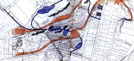
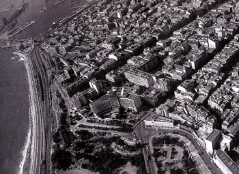
Se nos propone como tema de estudio la reordenación de un parque urbano existente en Barcelona: el Parc del Putxet. La principal peculiaridad del parque proviene del hecho que se sitúa sobre una de las últimas estribaciones montañosas de la sierra de Collserola. Se trata de una colina cuya superficie aproximada es de tres hectáreas y se halla totalmente rodeada por edificación residencial, vallado su perímetro y restringido su acceso por varias puertas. El parque es difícilmente detectable desde el entorno urbano próximo, únicamente se anuncia a través de estrechas fisuras abiertas en el continuo construido.

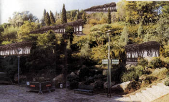
El interior del parque se recorre a través de una amplia red de caminos, que no presentan jerarquía alguna, que desaprovechan gran número de espacios de interés y cuyas pendientes en algunos tramos no son adecuadas para el público mayoritario del parque: personas de la tercera edad. En cuanto a la vegetación, presenta tal profusión de especies, tanto autóctonas como alóctonas que las imágenes que encontramos son en su mayoría contradictorias.

La idea del proyecto es la de restaurar el carácter natural del lugar.

Las premisas de partida:

- Trabajar a favor de la topografía.

- Revegetar con las especies originarias del lugar.

- Modificar los recorridos para establecer unos trazados lógicos.

- Aprovechar la gran variedad de espacios que ofrece el parque.

- Incrementar la accesibilidad al parque para optimizar el uso.

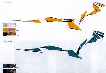
El proyecto estructura el parque a través de dos elementos:

- un sistema de terrazas, que aprovecha las ya existentes,

- un sistema doble de recorridos, que va trabando las terrazas, de manera que según formen parte de un recorrido u otro varía el carácter y formalización de las mismas.

El 1er sistema de recorridos lo constituye un conjunto de caminos paralelos situados a distintas cotas, pues se van adaptando a las distintas curvas de nivel. Este conjunto tiene como función poner en comunicación distintas partes del parque que se hallan a la misma cota, creando a su vez un sistema permeable a la ciudad, capaz de relacionar distintas partes del barrio entre sí. Es un sistema con vocación urbana. Se desarrolla en un plano horizontal o con pendientes inapreciables. su carácter más urbano se evidencia en el tratamiento dado a las superficies, mobiliario y vegetación.

El 2º sistema es un recorrido único, que no tiene el carácter de permeabilidad con el entorno, como en el caso anterior, su función es la de dar una coherencia interna a los recorridos y usos que se hacen en el lugar atendiendo a su especificidad – se trata de un elemento geomorfológico -. El camino se estructura atendiendo al criterio de mantener una pendiente constante entre 7.5% - 8%, para facilitar el acceso de personas de cualquier edad y condición.

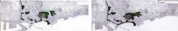
En cuanto a la vegetación, de momento se respeta la existente, pero se plantea su paulatina sustitución por especies propias del lugar: Pinus pinea, las nuevas plantaciones reforzarán la lectura topográfica, se reconocerán como bandas ascendentes y descendentes que recorren la montaña, entre la vegetación actual. Los pinos aparecerán asociados al primer sistema de recorridos. Asociados al segundo recorrido aparecerán plantaciones en mancha de olivos.

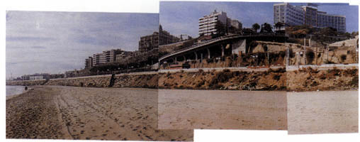
La presencia del parque en la ciudad, por las noches, se conseguirá a través de la prolongación visual de las calles en unos elementos luminosos que remarcarán la topografía accidentada del lugar.

Taller II: Workshop II: "Interventions in cultivated spaces".
Teachers: Olga Tarrasó, Jordi Henrich

The subject of study we were suggested was to remodel a city park in Barcelona, the Parc del Putxet. The main peculiarity of the park is the fact that it is sited on one of the last mountainous spurs of the Collserola range. This hill has a surface area of approximately three hectares and is completely surrounded by residential buildings. It is walled all around and can only be entered by the gates. Its presence is difficult to detect from the surrounding urban area as the park only announces itself by means of narrow fissures in the building continuum.

An ample network of paths without any hierarchy runs through the interior of the park, missing a great number of spaces of interest. In certain stretches their gradient is unsuitable for the majority of the park’s users: senior citizens. The vegetation shows such a profusion of species, both native and foreign, that the images we find are mostly contradictory.

The idea of the project is to restore the natural character of the place.

The initial premises are:

Work on behalf of the terrain

Replant with the original species of the place

Modify the paths to lay out logical routes

Take advantage of the great variety of spaces the park offers

Increase accessibility to the park to optimise its use

The project structures the park by means of two elements:

A system of terraces, making use of those that are already in existence

A double path system that links the terraces in such a way that their character and formalisation change according to which route is taken.

The 1st path system is made up of a set of parallel paths laid out at different levels, following the gradient curve. The function of this system is to communicate different parts of the park that are on the same level. At the same time, it makes the system permeable to the city and enables different areas of the district to relate to each other. This system, developed on a horizontal or only slightly sloping plane, has an urban vocation. Its more urban character is brought out in the treatment of the surfaces, furniture and vegetation.

The 2nd path system is a single route, without the permeability to the surroundings that characterises the first. Its function is to give internal coherence to the routes and uses of the place, paying attention to their specificity – it is a geo-morphological element. The path is structured on the criterion of maintaining a constant gradient of between 7.5% and 8% to facilitate access by persons of any age and condition.

As regards the vegetation, the existing plants are retained for the moment, but gradual replacement by native species is suggested. New plantings of Pinus pinea will reinforce the topographic reading of the place as they will be recognised as ascending and descending bands that travel across the mountain among the present vegetation. These pines will be associated with the first path system. Clumps of olives will also appear, associated with the second route.

The presence of the park in the city, at night, will be achieved through the visual prolongation of the streets by means of the lamps that will underline the steep terrain of this place.


120-05.jpg (12829 bytes)
Espacios libres previstos en el planeamiento / Open spaces provided for in the plan