Cabecera Park
Valencia
Arancha Muñoz Criado
Vicente Corell Farinós
|
|
|
|
Parque Cabecera
Cabecera Park Valencia |
Eduardo de Miguel Rabones
Arancha Muñoz Criado Vicente Corell Farinós |
| Premio
COACV 2003-2004/2003-2004 COACV Prize Espacios Exteriores/Exterior Spaces
|
|||
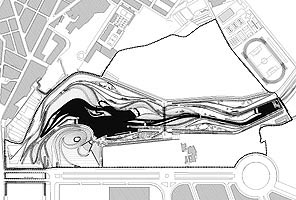
| El parque
se extiende a lo largo de más de un kilómetro del antiguo cauce del río
Turia en un espacio situado entre el borde de la ciudad y la huerta. Se
trataba de una zona muy degradada utilizada como escombrera y vertidos
incontrolados. El proyecto de parque público abarca la parte central de
un ámbito más amplio, definido por el PGOU como Parque de Cabecera y que
incorporará, en un futuro próximo, un bioparque y un parque de
atracciones, ambas actividades en régimen de concesión.
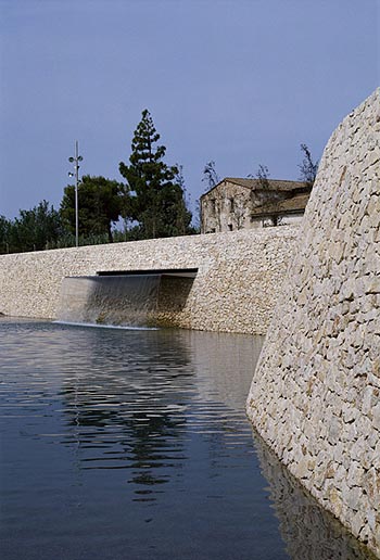
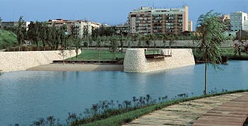
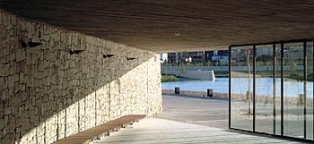
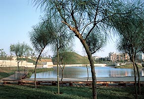
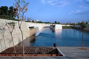
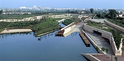
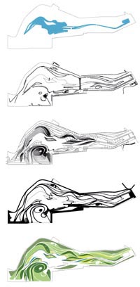
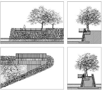
La idea del proyecto ha sido la transformación de este espacio en un bosque de ribera, propio del entorno de los ríos mediterráneos, en el que se funden vegetación, topografía y agua. Esta estrategia ayuda a resolver la transición entre el encauzamiento rígido del río Turia, construido en el siglo XVIII para proteger a la ciudad de sus avenidas y el cauce natural aguas arriba. El agua, la vegetación, la topografía y los muros de piedra seca, son los elementos estructurantes sobre los que descansa la concepción del parque. El trazado del parque remite a las formas sinuosas de los islotes que se formaban en el río con motivo de las crecidas. Según el carácter de las distintas zonas del parque, estos islotes pasan de ser pequeñas colinas recubiertas de vegetación en tierra firme, a introducir sus laderas en el agua, o formar auténticas islas en el lago. La colina-mirador, de planta ovalada, se constituye como el hito visual del parque al tratarse del punto más alto y resuelve el difícil cambio de trayectoria del antiguo lecho del río, un giro de 90º, antes de encauzarse para atravesar toda la ciudad hasta el mar. La piedra natural en los muros, detrás de los cuales se integran los equipamientos, la madera cepillada de ipe en los bancos y en las gradas del auditorio, los pavimentos de hormigón lavado en los espacios más urbanos, y acabados con gravilla de canto rodado o traviesas de madera reciclada para el resto de caminos y senderos que se deslizan longitudinalmente entre islas, muros y colinas, adaptándose a sus diferentes formas y geometrías, forman el espectro de materiales empleados en su construcción. |
The park covers over a kilometre of the former bed of the River Turia, in an area between the edge of the city and the surrounding market gardens. This was a very run-down area, used for unauthorised dumping. The public park is the central part of a wider project, the Cabecera or River Head park defined by the city plans, which will shortly include a biological park and a fairground, both privately-run. The idea for the park was to turn this space into a riverside wood, typical of the environs of Mediterranean rivers, blending vegetation, topography and water. This strategy helped to solve the transition between the rigid embankments of the River Turia, built in the 18th century to protect the city from flash floods, and the natural riverbed upstream. The water, the vegetation, the topography and the dry stone walls are the structuring features on which the concept of the park is based. The layout is a reference to the sinuous shapes of the little islands that formed when the river rose. Depending on the character of the different areas of the park, these islands are small hills on dry land covered in vegetation, slopes that enter the water or true islands in the lake. The oval lookout hill, the highest point of the park, constitutes its visual landmark and solves the difficult change in direction in the old river bed, which has a 90º bend before being channelled through the entire city down to the sea. The natural stone of the walls, with the equipment built in behind them, the planed ipe wood of the benches and the auditorium stands, the washed concrete paving in the more urban spaces and the rounded gravel or recycled railway sleepers on the remaining paths that glide between the islands, walls and hills, following their different forms and shapes, comprise the spectrum of materials employed in this work. |
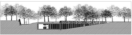
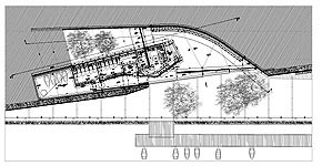
 Alzado/Elevation. Sección BB'/Section BB' Planta/Plan. Sección AA'/Section AA'
|
Promotor/Developer: Ayuntamiento de Valencia/Valencia City Council Situación/Location: Colaboradores/Collaborators: Aparejador/Surveyor: Contratista/Contractor Fotógrafo/Photographer |
 |
 |
 |